
Charts & Navigation
Invisible Boundaries, Invisible Risks
Millions of recreational boaters navigate the Florida Keys each year. Most have no idea where the reef ends and the sanctuary begins — because their charts don't show them.
The Navigation Gap
What Boaters Don't Know Can Hurt the Reef
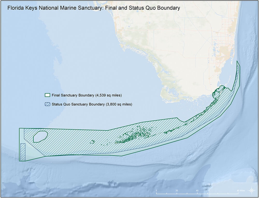
The Florida Keys National Marine Sanctuary encompasses 2,900 square miles of ocean, reef, and seagrass. Within it are multiple protection zones — from general use areas to no-take zones to areas where anchoring is prohibited entirely. These boundaries are legally binding and ecologically critical.
Yet the vast majority of recreational boating charts — including the electronic chart systems (ECS) and chartplotters used by millions of weekend boaters — either omit these boundaries entirely or render them in ways that are difficult to interpret at a glance.
The result: well-meaning boaters anchor on protected coral, drift into no-take zones, and ground on shallow reef structures they had no way of knowing were there. Vessel groundings are among the most destructive single events a reef can experience — and most are preventable with better information.
of sanctuary waters with complex, overlapping protection zones
The Problem in Detail
Six Ways Charts Fail the Reef
Missing Protection Zones
Most recreational chartplotters do not display Florida Keys National Marine Sanctuary zone boundaries, leaving boaters unaware of no-anchor, no-take, and wildlife management areas.
Incomplete Reef Mapping
Shallow reef structures, coral heads, and hardbottom areas are inconsistently charted. Boaters relying on depth soundings alone frequently ground on features that don't appear on their displays.
Lighthouse Context Missing
Historic aids to navigation like Carysfort Reef Lighthouse appear as generic symbols with no context about the surrounding reef structure, protected status, or ecological significance.
Outdated Data Layers
Electronic chart databases are updated infrequently. Reef conditions, sanctuary boundary revisions, and new conservation designations often lag years behind in consumer chartplotters.
Poor Visual Hierarchy
When protection zone data is included, it is often rendered in colors and line weights that blend with depth contours, making it nearly impossible to read at typical navigation zoom levels.
Mobile App Gaps
Popular boating apps used by casual day-trippers frequently lack any sanctuary or conservation layer, reaching the highest-risk audience with the least information.
Our Advocacy
What Better Charts Look Like
The Carysfort Reef Lighthouse Foundation advocates for specific, achievable improvements to recreational and electronic boating charts throughout the Florida Keys.
Mandatory Sanctuary Layer
All electronic chart systems sold or used in U.S. waters should include a standardized, always-visible Florida Keys National Marine Sanctuary layer showing all protection zone boundaries with clear visual differentiation.
Reef Hazard Overlays
NOAA and chart publishers should collaborate to produce high-resolution reef hazard overlays for the Florida Keys, identifying shallow coral structures, hardbottom areas, and known grounding sites.
Lighthouse Heritage Markers
Historic lighthouses including Carysfort should be marked with enhanced symbols linking to information about the surrounding reef, protection status, and the lighthouse's historical significance.
Real-Time Condition Alerts
Chart systems should integrate NOAA and sanctuary alerts for active coral bleaching events, temporary closures, and environmental emergencies — giving boaters real-time context for their navigation decisions.
Consumer App Standards
NOAA should establish minimum data standards for recreational boating apps operating in National Marine Sanctuary waters, ensuring that casual users receive the same protection zone information as professional mariners.
Mariner Education Integration
Chart publishers and app developers should integrate brief, contextual education about reef ecosystems and sanctuary regulations directly into the navigation interface — at the moment and place it is most relevant.
Working with NOAA
The Data Exists. It Needs to Reach Boaters.
NOAA's Office of Coast Survey and the Florida Keys National Marine Sanctuary program maintain detailed, accurate geospatial data for reef structures, sanctuary boundaries, and protection zones. This data is publicly available and regularly updated.
The gap is not in the data — it is in the pipeline from federal databases to the chartplotters, apps, and paper charts that recreational boaters actually use. Closing that gap requires advocacy, industry partnerships, and regulatory standards.
The Carysfort Reef Lighthouse Foundation is working with NOAA, the Florida Keys National Marine Sanctuary, and chart publishers to accelerate the integration of sanctuary data into consumer navigation products.

Every grounding is a preventable tragedy. The reef doesn't grow back on a human timescale. Better charts are not a luxury — they are a conservation tool.
— Carysfort Reef Lighthouse Foundation
Navigation Resources
Official Charts & Data
NOAA Office of Coast Survey
Official source for U.S. nautical charts, electronic navigational charts (ENCs), and chart update notices.
Florida Keys National Marine Sanctuary
Sanctuary maps, zone boundaries, regulations, and boater education resources.
NOAA Chart Viewer
Interactive online viewer for official NOAA nautical charts of the Florida Keys and surrounding waters.
Sanctuary Watch
NOAA's real-time monitoring portal for Florida Keys water quality, coral conditions, and environmental alerts.
Reef Environmental Education Foundation (REEF)
Citizen science reef surveys and fish population data for the Florida Keys.
Florida Fish and Wildlife Conservation Commission
Florida boating regulations, no-wake zones, and marine protected area information.
Advocate for Better Charts
Help us push for the chart improvements that will protect the Florida Keys reef for future generations. Sign up for advocacy updates, support our work, or contact your representatives.